Home /
Expert Answers /
Earth Sciences /
chapter-19-figure-19-1-stages-of-continental-rifting-are-shown-in-this-series-of-diagrams-the-major-pa354
(Solved): chapter 19 FIGURE 19.1 Stages of Continental Rifting are shown in this series of diagrams. The major ...
chapter 19
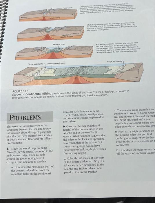
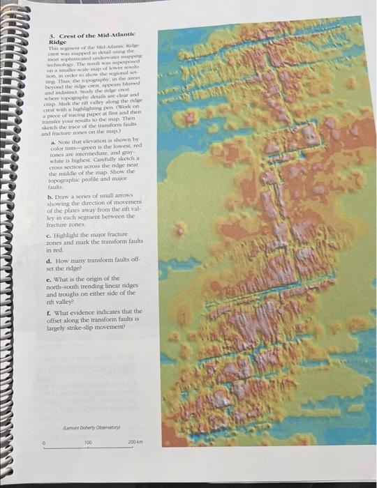
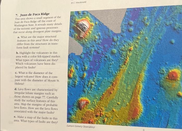
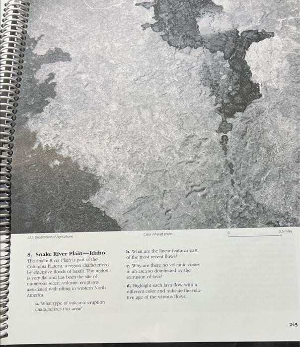
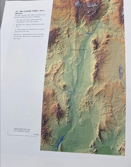
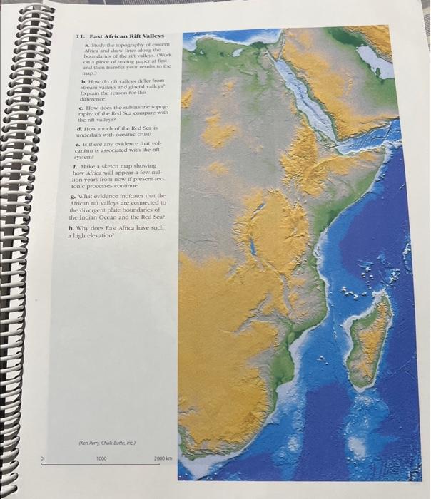
FIGURE 19.1 Stages of Continental Rifting are shown in this series of diagrams. The major geologic processes at divergent plate boundaries are tensional stress, block faulting, and basaltic volcanism. PROBLEMS This exercise introduces you to the landscape beneath the sea and to new information about divergent plate margins that we have learned from studies of both the ocean floor and rift valleys on continents. 1. Srudy the world map on pages , paying special attention to the mid-oceanic ridge. Trace its path around the globe, nocing how it changes from one area to another. a. How does the "mountain belt" of the oceanic ridge differ from the mountain belts on the continents? Consider such features as acrial extent, width, height, configuration, and structunt features expressed at the surface. b. Compare the sine (width and height of the oceanic tidge in the Atlantic and in the east Pacific cocans. What evidence suggests that the ridge in the Pacific is spreading faster than that in the Atlantic (A slow-moving tidge would have more time to baild up higher than a fast-moving ridge) c. Color the ritt valley at the crest of the occansic ridge red. Why is a rift valley better developed in the Atlantic and Indian ridges compared to that in the Pacific? d. The oceanic ridge exiends into continens in western North Americr., and in east Africa and the Red Se:L. What stuctural and topographic featunes occor sthere the e. How many triple junctions on the oceanic ridge can you find on the global map? Why do they occur in the oceans and not on continents? f. How does the tidge terminat off the coast of northern Califor
3. Crest of the Mid-Atlantic Fidge and infistinct. Snuly ilse niflec onst crisp. Mtark ithe nin valles along the ndfes a peces of tracing puper at tinst and thet transier your woutis to the nap. Tien sketch the trice of the tranforti fratis. and fractsire rones on the map? a. Weec that efervion is ahown by color tins-green is the lowest, red tones are internediate, and graywhite is hiplest. Candully shecti a cross section across the ridge near the middle of the map. Shore the toposerplise protile and mator fauks. b. Druw a series of small artows showing the difection of movement of the plates away from the rift val. ley in each segrnent between the facture zones. c. Highlight the major frmctuite zones and mark the transform fauls in ted. d. How many traniform faulis oxtset the nidge? c. What is the origin of the noth-south trending linear ndges and troughts on either side of the nift valley? f. What evidence indicates that the offset along the transform faults is largely strike-slip movement?
KC Mocolonaid 7. Juan de Fuca Ridge This area shows a small segment of the fuan de Fuca Ridge off the coast of Washington State. It reveals many details of the tectonic and igneous processes that occur along divergent plate margins. a. What are the major structural features in this area? How do they differ from the structures in transform fault systems? b. Highlight the volcanoes in this area with a color felt-tipped-marker. What types of volcanoes are they? Which volcanoes have been displaced by faulis? c. What is the diameter of the largest volcano? How does it compare with the diameter of Mount St. Helens? d. Lava flows are characterized by irregular lobate margins such as those shown on page 77. Carefully study the surface features of this areat. Map the margins of probable lava flows. How are the lava flows associated with the major faults? e. Make a map of the faulis in this area. What types of faults are they?
8. Snake River Plain-Idaho The Snake Fiver Plain is part of the Columbia Plateau, a fegion characterized by extensive floods of basalt. The region is very flat and has becn the site of numerous recent volcanic cruptions associated with rifing in westem North Americat a. What type of volcanic eruption characterizes this area? b. What are the linear features east of the most recent flows? c. Why are there no volcanic cones in an area so dominated by the extrusion of lava? d. Highlight each lava flow with a different color and indicate the relative age of the vanous flows.
10. Rlo Grande Walley; Wew Mesico a. Maps the fralis that maik the: anteis 6. What nipe of volionion is antos: akd whithe onl? acroes the rin in che content part of thinimp:
11. East African Jein Valleys on a picese ed encine puper at first thape Explain the teakras for then sifference c. How dock the suburarine lopoys? the nd valiegs? d. thow much of the flect sea is e. Is there any covilence that vercaninm is aswosiased with the rif systeme f. Make a siketis map showing: how Afrsca will appear a few nul lon years from now if puesernt lextonic processes continue: 8. What evidence indieases that the Arricun mif valley's are congecticed to the divergent plate boxinclaries of the Indian Ocean and the Hed sea? h. Why does Eas Afnea have such a high clesation?