(Solved): Exercise 34 Problems-Part I Name Section In the following problems you will compute the gradient ...
Exercise 34 Problems-Part I Name
◻Section In the following problems you will compute the gradients of Mauna Loa in Hawail, Mount Vsevidof in Alaska, and SP Mountain in Arizona. (You may also determine the elevation changes and distances needed to calculate these gradients by using Google Earth
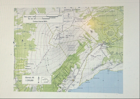
^(™ ).) The recommended starting point and distance to measure are given for all three volcanoes. Using Map T-1D, the "Hawail, Hawail," topographic map (scale
1:250,000; contour interval 200 feet), calculate the gradient of Mauna Loa (
19^(**)(28)/(17)mN,155^(**)3541mW) roughly along line AB, from the 5000 , contour (near Point A) toward the summit. On the edge of a piece of paper measure out a distance of 10 miles using the graphic map scale, and then determine the elevation change over that distance (this will not reach the summit).
◻(Elevation Change)
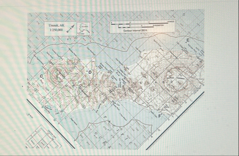
feet -:(10)/(◻)(Number of Miles) feet/mile (Gradieat) 2. Using Map T-2.D, the "Umnak, Alaska," topographic map (scale 1:250,000; contour interval 200 feet), calculate the gradient of Mount Vsevidof ) roughly along line CD, from the 1000 contour (near Point C) toward the summit. On the edge of a piece of paper measure out a distance of 2 miles using the graphic map scale, and then determine the elevation change over that distance (this will not reach the summit).
q,feet
-:
q,2
q,feet/mile (Elevation Change) (Number of Miles) (Gradien)Using Map T-20, the "Umnak, Alaska," topographic map (scale 1:250,000; contour interval 200 feet), calculate the gradient of Mount Vsevidof W) roughly along line CD, from the 1000 contour (near Point C) toward the summit. On the edge of a piece of paper measure out a distance of 2 miles using the graphic map scale, and then determine the elevation change over that distance (this will not reach the summit).
◻feet
-:
q,
=
◻feet/mile (Elevation Change) (Number of Miles) (Gradient) Using Map T-22b-, the "SP Mountain, Arizona," quadrangle (scale
1:24,000; contour interval 40 feet), calculate the gradient of SP Mountain ) from the north base of the cone (at the
(6200)/()contour) toward the crater rim. On the edge of a piece of paper measure out a distance of 0.2 miles using the graphic map scale (inside front cover of Lab Manual), and then determine the elevation change over that distance (this will not reach the summit).
◻feet
(0.2)/()==
q,feet/mile (Rlevation Change) (Number of Miles) (Gradient) Which of the three volcanoes has the steepest slope? b. Why does this kind of volcano have the steepest sloper c. Which of the three volcanoes has the gentlest slope?
q,d. Why does this kind of volcano have the gentlest slope?